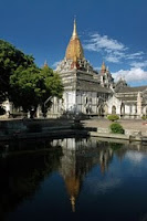
The varied and rugged geography of Burma has done much to shape the vibrant ethnic diversity that exists in the country today. Across the centuries the great horseshoe of mountains that surround the central Irrawaddy River valley has acted as a defense barrier to the invading armies of foreign powers. Simultaneously, the same mountains and deep river valleys have witnessed the constant migration of different ethnic peoples of almost every kind. Some have passed through, some have intermarried or merged with other cultures and peoples along the way, while others have retreated into remote mountains and forests, where many unique cultures have evolved and still survive.
The different terrains often reflect the histories and economies of the different ethnic peoples. In the far north of Burma, where the Kachins and Nagas live, there are snow-capped peaks which stretch into the foothills of the Himalayas, while in the far south, amongst the Mons, Tavoyans and Salum sea- gypsies of Tenasserim, there are lush rain forests and intense tropical heat. On the fertile plains of the Irrawaddy Delta rice is the major crop, and this fact earned Burma the nickname of the ‘rice-bowl of Asia’ in British days. But rich natural resources still remain, whether in the jade mines of Kachin State, the ruby mines of Shan State, or in the unexploited seas off the Rakhine coast.
Settlement patterns have also had an important impact on the development of social and political cultures. While the Mons and Burmans settled on the sun-baked central plains, practicing wet-rice cultivation and establishing great city- kingdoms, the Shan occupied highlands valleys across the north- neast Mountains, where many small fiefdoms and constantly changing confederations emerged. Further up the mountains, minority peoples such as the Kachins, Was and Chins remained mostly in the forests where they practiced shifting cultivation in villages that were often autonomous
.In the process of such movements, individual ethnic groups developed a very different array of local cultures. Karen migrants, for an example, who passed into south-east Burma down the eastern Salween River valley mostly stayed in hills, where an extraordinary variety of sub-cultures evolved in the rugged mountains of Kayah State and hill-tracts above Toungoo. By contrast, Karen settlers who moved down the central Irrawaddy and Sittang River valleys into the plains areas of Lower Burma changed over the centuries to wet-rice cultivation, Buddhism and many of the daily practices of their Mon and Burman neighbors.From this complex past, ethnic places and names have yet to become standardized. Burma has itself been known by different names and pronunciations in the past, as have cities, such as Rangoon and Sittwe, or different peoples, including the Shan or Padaung. In 1989, the ruling State Law and Order Restoration Council changed the name of Burma to Myanmar for official international usage. It also introduced new transliterations for many other names, including Bama for Burman or Burmese, Ayeyarwady for Irrawaddy, Pathein for Bassein, and Mawlamyine for Moulmein. Such titlesw, however, are yet to be widely known.


0 comments:
Post a Comment