Burmese marionette theatre – or yok-thei pwe – was developed during the reign of King Bagydaw in the early nineteenth century and was the forerunner of live theatre. There are still a few master puppeteers in Burma, but the skill is dying out and efforts have been made to train youngsters in the art.
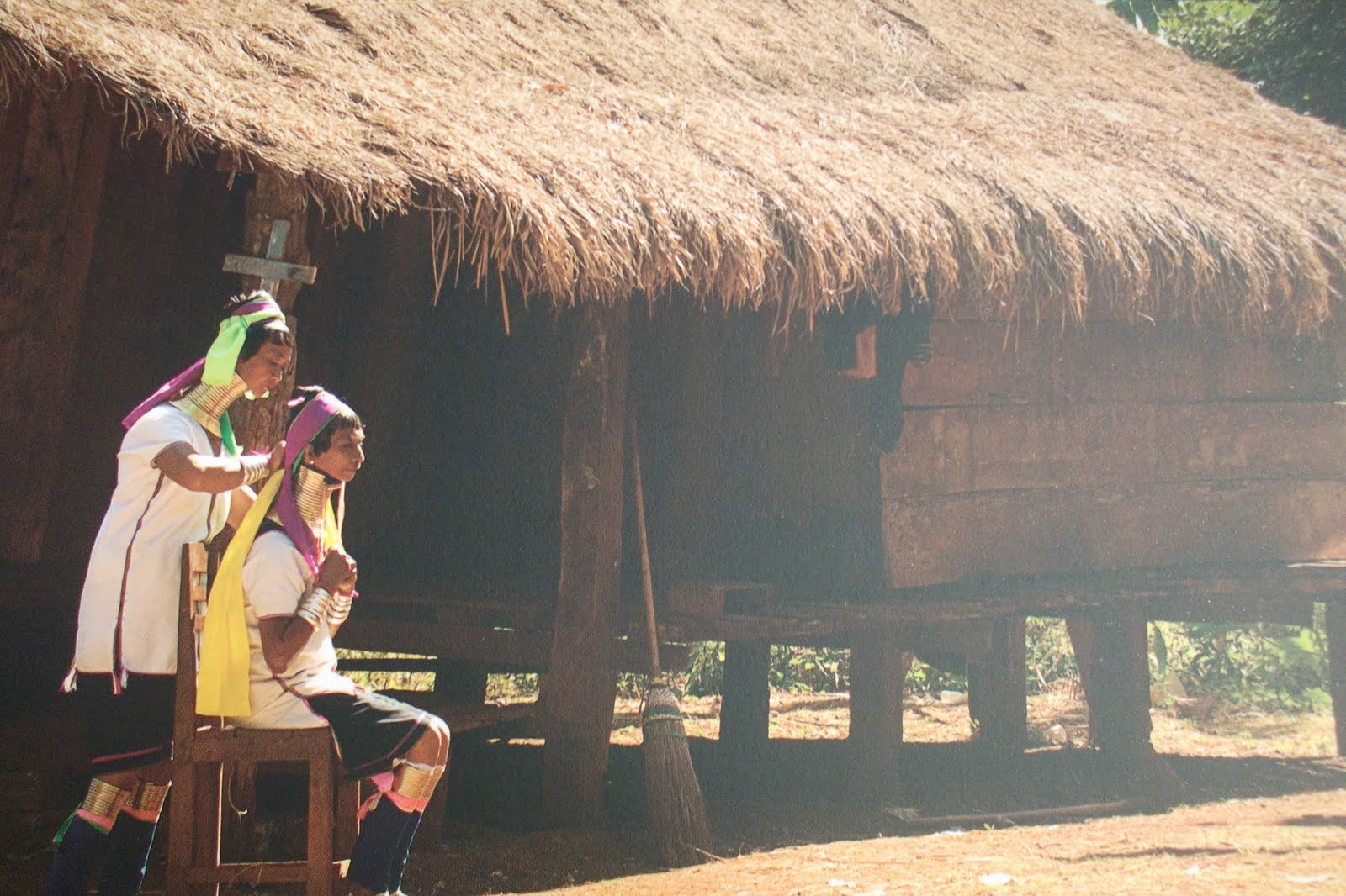
The Padaung are found in a 150-square-mile area of Kayah State and Shan State, west of the Salween river and around the Pekon hills, which rise to 5,000 feet. For centuries they have been objects of curiosity and were once brought to the palace of the King of Mandalay for inspection. They are part of the Kayan subgroup of Karens. Although known in the world as Padaung, they call themselves Ka-Kaung, which means people who live on top of the hill.
The Padaungs are often nicknamed ‘giraffe women’ or the ‘long-necked Karens’ because of the custom of encasing the neck in brass coils. The practice is fast disappearing, and today can only be found in a few villages. When a girl is aged between five and nine, her neck is rubbed with ointment said to be made of dog fat, coconut milk and royal jelly, and the first neck ring is fitted. After two years, the next set of coils is added and every year therefore she gains a new set until she marries.
Intha people can be found living on or around Lake Inle in Shan State. Speaking a distinctive and unusual Burmese dialect, there is mystery over their origins in this area. Like the Pa-Os and Taungyos, it is thought that they are arrived from Lower Burma many centuries ago. By one account, they are descendants of southern Burmese who migrated north during the reign of the King Narapatisithu (1174-1210), although some scholars believe they stem from slaves taken captive during on-and-off wars with the Mons and Tavoyans.
The Intha are famous for their highly individual rowing technique. Fisherman wrap a paddle around one hand and leg and use this to propel the boat, while balancing precariously on the other. This position leaves them with one hand free, allowing them to drop a large conical new over passing fish in the shallow waters of the lake.
Mount Popa is an volcano whose outer casing of soil has been washed away, exposing the rock core which rises 1,500 feet above the plains outside Bagan. Traditionally, every Burmese king would make a pilgrimage to Mount Popa, the legendary home of the Nats or spirits. To consult them before his reign could begin. Pilgrims visit Mount Popa in the Burmese month of nayon (May to June) to celebrate the annual festival of spirits.Of the thirty-seven Nats, the two most revered are the Mahagiri Nats who live in Mount Popa. Legend has it that they were a brother and sister who lived in the sixth century; the brother was reputedly burned alive in a flowering jasmine tree by the king, and his grief-stricken sister, the king’s wife, threw herself into the same fire.
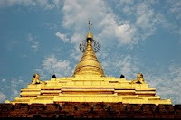
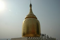
Kyaikitiyo Pagoda is, along with Bagan and the Shwedagon, one of country’s most wondrous sites. A small stupa is perched on the top of the gargantuan ‘Golden Rock’, a huge boulder covered in gold leaf which a balances precariously on the edge of a cliff at the top of Mt Kyaikto. At dawn, as pilgrims light incense and fires around its base, the huge golden dome shimmers in the early morning light, catching the first rays of sunshine.
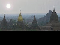
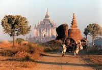
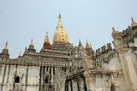
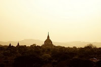
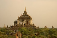
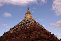
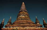
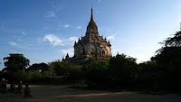
Dhammayangyi Pagoda was built by King Narathu in the mid - twelfth century and is the largest of the pagodas found on the plains of Bagan. The so-called city of ‘four million temples’ on the banks of the Irrawaddy River was founded in the mid - ninth century by the Burmese and was sacked by Kublai Khan and his Mongol armies in 1287. Today, the ancient city is uninhabited and the remnants of thousands of temples, Nat shrines and pagodas stand alone across the arid plains. The reclining Buddha is a common pose, representing the Buddha’s attainment of nirvana.
The upper and central plains of Burma are the traditional home of the Burma, a Tibeto-Burma people who migrated from the north and China- India borderlands up until the eleventh century AD. The Burmese ( or Bamas or Myanmar ) established their greatest capital at Pagan between 1044 and 1287 AD on the banks of the Irrawaddy. Later capitals were built at Ava, Amarapura, Sagaing, Mandalay, and Toungoo.
Today, Burmese form the largest ethnic group in the country, with 50 million people – about 60 percent of the population – speaking only their language, Burmese. In the past century, many minority groups, especially Mons and Karens, has become assimilated as Burmese migrants spread into new areas.
Like the Mons, the rich culture of the Burmese, who are strongly Buddhist, shows influences of Indian civilizations. These include Pali script (derived from Sanskrit), cosmetology, philosophy and statecraft, art, medicine and architecture.
The varied and rugged geography of Burma has done much to shape the vibrant ethnic diversity that exists in the country today. Across the centuries the great horseshoe of mountains that surround the central Irrawaddy River valley has acted as a defense barrier to the invading armies of foreign powers. Simultaneously, the same mountains and deep river valleys have witnessed the constant migration of different ethnic peoples of almost every kind. Some have passed through, some have intermarried or merged with other cultures and peoples along the way, while others have retreated into remote mountains and forests, where many unique cultures have evolved and still survive.
The different terrains often reflect the histories and economies of the different ethnic peoples. In the far north of Burma, where the Kachins and Nagas live, there are snow-capped peaks which stretch into the foothills of the Himalayas, while in the far south, amongst the Mons, Tavoyans and Salum sea- gypsies of Tenasserim, there are lush rain forests and intense tropical heat. On the fertile plains of the Irrawaddy Delta rice is the major crop, and this fact earned Burma the nickname of the ‘rice-bowl of Asia’ in British days. But rich natural resources still remain, whether in the jade mines of Kachin State, the ruby mines of Shan State, or in the unexploited seas off the Rakhine coast.
Settlement patterns have also had an important impact on the development of social and political cultures. While the Mons and Burmans settled on the sun-baked central plains, practicing wet-rice cultivation and establishing great city- kingdoms, the Shan occupied highlands valleys across the north- neast Mountains, where many small fiefdoms and constantly changing confederations emerged. Further up the mountains, minority peoples such as the Kachins, Was and Chins remained mostly in the forests where they practiced shifting cultivation in villages that were often autonomous
.
In the process of such movements, individual ethnic groups developed a very different array of local cultures. Karen migrants, for an example, who passed into south-east Burma down the eastern Salween River valley mostly stayed in hills, where an extraordinary variety of sub-cultures evolved in the rugged mountains of Kayah State and hill-tracts above Toungoo. By contrast, Karen settlers who moved down the central Irrawaddy and Sittang River valleys into the plains areas of Lower Burma changed over the centuries to wet-rice cultivation, Buddhism and many of the daily practices of their Mon and Burman neighbors.From this complex past, ethnic places and names have yet to become standardized. Burma has itself been known by different names and pronunciations in the past, as have cities, such as Rangoon and Sittwe, or different peoples, including the Shan or Padaung. In 1989, the ruling State Law and Order Restoration Council changed the name of Burma to Myanmar for official international usage. It also introduced new transliterations for many other names, including Bama for Burman or Burmese, Ayeyarwady for Irrawaddy, Pathein for Bassein, and Mawlamyine for Moulmein. Such titlesw, however, are yet to be widely known.